Carrying Mooring Chain

Setting up a mooring to anchor your boat is a safe and effective way to anchor for extended periods of time. The only problem is you need a hefty amount of chain to do such an operation!

We carry 300 feet of 5/16" G70 chain, which weighs about 300 pounds up in the forepeak. This works well for deploying the ground tackle, but it causes some issues with weight distribution. Luckily, we are a very heavy displacement boat, so we are much less sensitive to weight distribution and can get away with adding 300 pounds to the tip of the bow.

The mooring chain we carry is 200 feet of 3/8" G43 Mooring Link, which weighs about 300 pounds as well. If we place this chain in the forepeak with the regular chain, we would then have 600 pounds added to the tip of the bow! Mooring chain isn't as commonly used as the regular rode, so we feel that we don't need the easiest of access to it. 

The infrequency of need and planned use of this chain means that it can be stowed in a harder to reach place that better centers the weight in the boat. Obviously, the most centered of places in the boat is the center of the boat, and the lower is the better; so our plan is to store the mooring chain in the bilge, next the the motor bank batteries. This place is low, centered, and still available to access. When we reach a place where we would be using it with some frequency, we can always store it on the deck until we get to the next site where we need to deploy it. 

When we have a long ocean crossing ahead of us, we can then stow it below in the bilge where it will keep the weight low and centered.

Work vs. Cruising

Deciding when to go cruising is a difficult decision that can be made very simple and easy to resolve. Cruising takes all your time. You will be away from work and unable to go to work for a long period of time. This means that you will have to decide if you want to go cruising or go to work. I know, sounds like a really tough decision so far, but it can get a whole lot simpler.

You might feel that you have to go to work because you have all of these bills to pay, and you need money to pay the bills, therefore you need to go to work. The trick is to evaluate which bills are bills for you to live and which bills are bills you pay to go to work.

This might sound ridiculous, that you would pay bills to go to work, but this sadly is the truth. Expenses like your vehicle are needed because you need a car to get to work. Without a car, you won't be commuting to work everyday, so you won't be able to keep your job. But if you don't have that job, then you don't need the car!

If you don't have a car, you don't have to pay for fuel, maintenance, and most of all, insurance! All these expenses that are tied to the car instantly disappear. At the same time, subscriptions to magazines will also be terminated as you won't be there to collect your mail.

In the end, the only real expense that you will have that is an expense of yourself is food that you buy to eat and feed yourself. Everything else becomes superfluous and is nothing more than a drain on your earnings. When you cut out all of these expenses that you incur to go to work, you will see that life is actually very inexpensive and that your money will last a lot longer than you might have first thought.

So, if work is so expensive, and cruising is so cheap, why work?

Weather Routing and Barometers

After our fateful storm off "The Graveyard of the Atlantic" where we headed out into what seemed like calm weather and insufficient wind to carry us the needed miles, followed by a drawn out and intense storm; we have started looking into a proper weather routing system.

A quick google search of weather routing will yield a wealth of options, all are programs and none are information. I thought this to be rather odd, because I wanted to learn more about weather routing and not ask a program for an answer.

Most of these programs charge for their use, but some of them are free! Now, having a good weather program sounds great when you are on land and connected to the marina's WiFi; but when you are offshore, everything changes! Power to run your computer becomes a taxing draw on your battery bank and all this distance from shore means that WiFi signals are a faint memory. Getting internet on your boat when you are still close to shore is possible by using your cell phone as a hotspot, but when you are out of range of cell phone service, the solution is very expensive.

Iridium Go is a viable solution until you price the package out. The unit itself costs around $1,000 and the subscription costs between $50 and $200 per month, depending on which plan you sign up for. Mind you, this unit and plan are considered to be the most economical method of getting internet on your boat while out at sea! 

So, the weather routing software is expensive, and the connectivity to use them where you would need them is also expensive. Instead of bursting our budget of $500 per month, I decided to dig a bit deeper. While these programs calculate the best route to get from Point A to Point B, the program itself was written by a human, so there must be some theory that the programmer used to base the calculations on.

Playing around with a few programs, I noticed a trend emerging with the route that they would suggest. They all seemed to follow the 1020mb isobar line. Any two points, anywhere on the map, the route always seemed to follow this isobar as best it could. This was my first clue into an enlightening discovery.

While 1020mb may seem like an arbitrary isobar, this region is known for having mild and steady winds. If the pressure is greater than 1020mb, you risk reaching the center of a high pressure system where the wind vanishes, and if you venture into areas where the pressure is less than 1020mb, you risk running into a low pressure system with its associated storm conditions. It seemed that there was something magical about 1020mb.

In further reading, I found a review of 5 popular (payment required) weather routing programs posted by Sail Magazine.At the end of the review, the author noted that all of these programs  "...aim for a course very close to the 1020mb pressure isobar. There’s something to be said for the old-timer’s simple route planning." (Source: https://www.sailmagazine.com/cruising/weather-routing-101-part-2)

That line: There's something to be said for the old-timer's simple route planning. That stuck out to me as it confirmed that the weather routing programs that charge are also following along with the 1020 isobar line! 

When following this line, the winds appear to be steady and uniformed in the same direction as it revolves around a high and low pressure system. The winds circulating around a high pressure system will always rotate clockwise while the winds circulating around a low pressure system will always rotate anti-clockwise (in the Northern Hemisphere). Knowing this, it is possible to pick a downwind route from any Point A to Point B by following the 1020mb isobar around high and low pressure systems!

A while back, my dad offered me his grandfathers barometer to take with us on our voyage. At the time I declined the offer because I didn't see an immediate need for it and didn't want to risk its safety while on board. I would forecast the weather by looking at the clouds and found no need for a barometer as the clouds would tell me if the pressure was rising of falling based on their formations. 

Now that I know we want to follow the 1020mb isobar, I suddenly had a use for a barometer and took my father up on the offer to borrow his grandfathers barometer (my great-grandfather). The line from that review "old-timer's simple route planning" struck in my head as I looked at the face of the barometer!

FullSizeRender.jpg

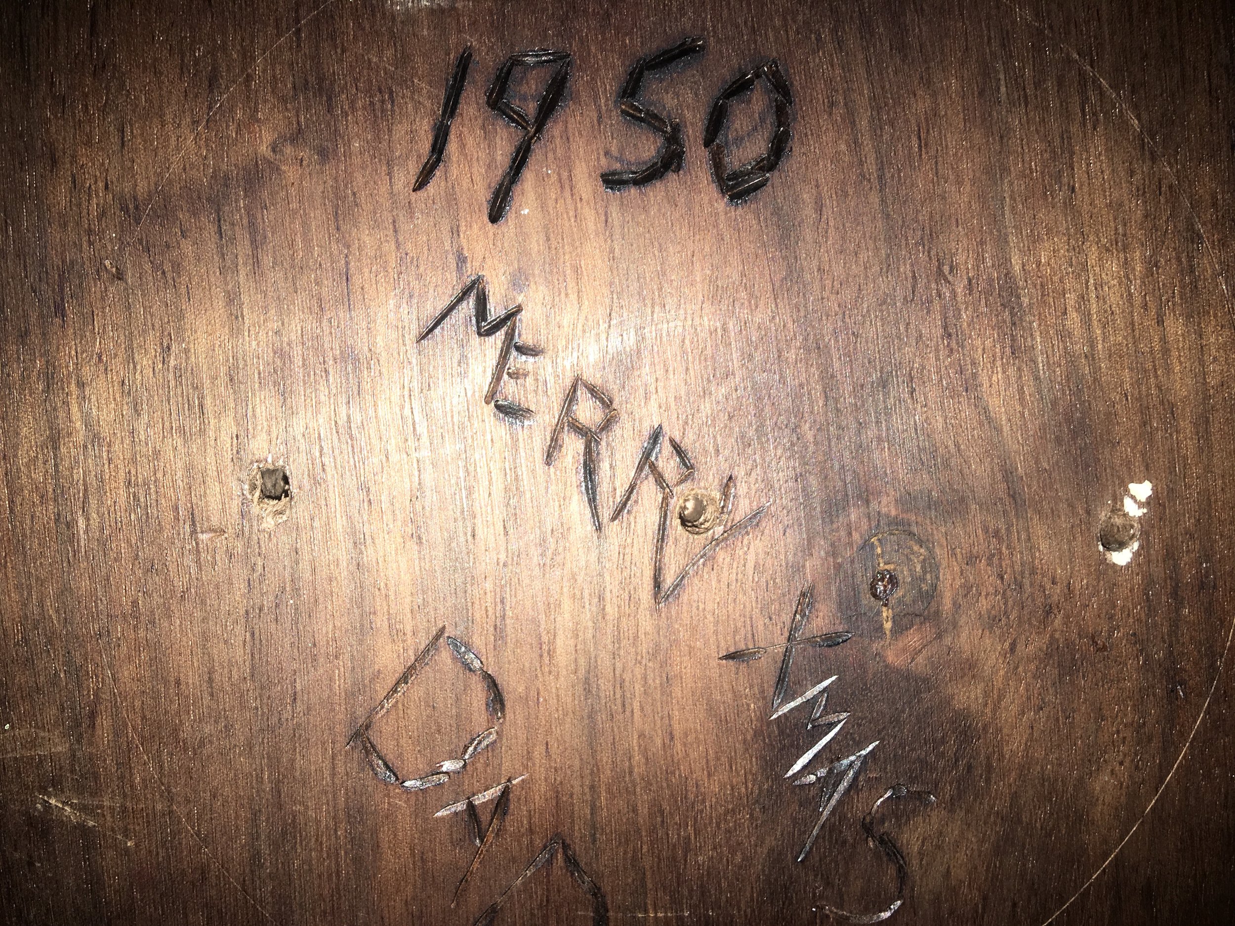
This barometer is certainly old, being a gift from my grandmother to her father in 1950, about 68 years ago!

IMG_1225.JPG

Note how under the 1020 millibar number, the word is "Fair". Seems that the old-timers made barometers and weather routing simple and easy to do. Keep the needle on "Fair" and if the pressure starts to change, alter course based on the wind to bring your yacht back into the "Fair" isobar.

This is easy to do without any fancy weather instrumentation or connectivity, all you need to do is stand outside and point! Thanks to the Coriolis Effect, when you stand face into the wind and extend your right arm straight out to your side and point, you will be pointing at the center of the low pressure that is causing these winds.

If the pressure is dropping, you are too close to the low pressure system and need to alter course away from it. If the pressure is climbing, you need to sail closer to the low pressure system.

The concept sounds simple, and if you look at current weather charts, you will see that the winds along the 1020mb isobar seem nice, ranging from 15-20 knots of wind along the entire route; but reality always has a way of rearing its ugly head.

Weather is not stationary. The 1020mb isobar will not stay where it is and allow you to sail around the world along this magical corridor of good weather. Nay, it will move around as the high and low pressure systems of the world dance around the surface of the Earth, causing the isobar to move, sometimes quicker than you can move your yacht. This means that while you may intend to stay in the 1020mb isobar, the 1020mb isobar may move away from you at a speed you can not match, and you will get caught in foul weather from time to time as you voyage.

This is a fact of cruising, but knowing what to look for in the weather and how to route your course to improve your chances of good weather is imperative to a happy cruising experience.

So, before you sign up for a complicated and expensive weather routing program and service, consider doing what the old timers used to do: sail where the weather is "Fair" on their barometer.

Free Weather Routing Software and How To Use It

In the world of weather routing, subscriptions and expense seem to be an accepted reality. All the "Free" programs simply let you look at the awesome software, but charge you to get any actual information out of them. In my quest for a budget friendly version, I discovered a free (and I mean completely free) program. It is a bit complicated, but I will walk you through all the steps involved in getting your own personal weather routing information!

I will include all the downloadable files on this page, as well as links to the original pages that have the information and links.

The free weather routing program is called "Bluewater Racing" and it is available for download at: http://bluewaterracing.com/index.php?option=com_phocadownload&view=category&id=1:windows&Itemid=66

Weather Download.png

Simply click the "Download" button for the Full Version and install it like any regular program you install on your computer.

This program is the weather routing software that will run the calculations based on the weather data that you give it. When you open the program, it will look something like this:

Weather Program 1.png

Now, this program is easy to use, but there is some learning required to get the most out of the program. I highly recommend running the tutorial which can be found here: http://bluewaterracing.com/index.php?option=com_weblinks&view=category&id=38&Itemid=62

Having the program may seem simple, but it is only part of the equation. The other part of the equation is the wind data in the form of a GRIB file. Some places offer these files for a fee, but once again, you can get them for free by emailing your request to "query@saildocs.com".

The way it works is you compose an email to query@saildocs.com where you ask for the weather pertaining to a specific area. The email looks something like this:

Weather Program 2.png

No subject is needed for the email. Simply type "Send gfs:(and then the coordinates for the area in question with no spaces)"

In this example, I am requesting an area from 40N down to 10N, and from 62W over to 82W. Separate the coordinates with comas, but do not use any spaces, so: 40N,10N,82W,62W

Basically, the formate is: (Top Coordinate),(Bottom Coordinate),(Right Coordinate),(Left Coordinate)

Then you click send, and your strange little email goes off into the internet; quickly replied by a machine which will send you a GRIB file as an attachment.

Weather Program 3.png

Now, click on the attachment and download it, then open it in the "Bluewater Racing" program.

Weather Program 4.png
Weather Program 5.png

Now, you can see displayed on your free program all the wind information for the area you wish to sail. 

After all these steps, you finally get to begin your weather routing software adventures!

Weather Program 6.png

Zoom in on the area you want to start your voyage from and click on "Edit" at the top menu. Then, Right Click on the screen where you want to begin your journey and select "New Route". This will give you a starting point. Next, zoom out until you can see your destination on the entire page. You will Left Click near your starting position and hold the Left mouse button and drag it towards your destination. This will generate the next point and you can then drag it to the destination. If no point forms, then you are too far from the first point, so try again a bit closer to it.

Weather Program 7.png

Now, you need to "manage the route" by clicking on "Tools" and then "Route Manager".

Weather Program8.png
Weather Program9.png

Now you will click "Opimize" and let the program run its magic! 

An important thing to note, is that this program comes pre-installed with the Polar Chart Data for a J120, which is a pretty high performing yacht. If you are cruising in one of these: Congratulations! If you are not cruising in one of these, then you will need to program in your own polar information. I created one polar chart for Wisdom which is a full keeled cutter, with much slower numbers than the J120, and I also created a polar chart that will trick the program into only providing you with a downwind route!

Save this file in the Polar files of Bluewater Racing, and use it to route yourself going only downwind routes.

Weather Program12.png

With the "Downwind Only" route saved, click on "Options" and where it says "Boat Type" type in "downwindonly" and this will load the downwind polar data onto the program.

Weather Program11.png

With the data entered, then click optimize and observe the time that it will take to make the run. "r1" will display a route that is direct. "r1_0" will display the "optimized" route to your destination.

You can see how the J120 would get there in just over 3 days, but the downwind boat will get there in just under 13 days!

Weather Program13.png

The straight line is the route planned without optimization, while the other route that goes all over the place is the downwind route.

By using this program and the GRIB files retrieved by emailing query@saildocs.com, you are able to plan when to leave and what route to take, all for absolutely free!

Joyner Marina, NC

While cruising down the ICW, we decided to go home for the holidays and visit our families and pets. To do this, we needed to leave our boat somewhere safe and affordable. We were close to Cape Fear, so we decided to pull into Joyner Marina. 

Having lived aboard for five years, I know a nice marina when I see one! The piers were floating so you don't have to worry about your dock lines as the radical tide grew and fell by over 5 feet. The quality of the wood and woodwork of the piers construction was an entirely different level to anything I have ever encountered! The boards on the pier looked like they were put together by a professional yacht joiner. Each board flowed effortlessly and flushly into the next, and at the edge of the marina was another trim board to finish up the dock.  

While a marina might just be a collection of piers and boats, this is not all that makes a marina great; it's the liveaboards that make the difference. Next to us, on a 37 foot Egg Harbor, was a lovely couple named Wes and Blair. They have two dogs and knew all the fun places to go in town for a good night. We would all go into town and eat at the local burger shacks and then pop over to the Fat Pelican, a famous dive bar, where you pick your own beer out of the giant walk-in cooler.  

Our other neighbor was Dale, who had been following us on YouTube and was very excited to see us arrive and be tied up near him. Dale was a wealth of information about the hydrography of the ICW and how to best plan the safest and least eventful journey down the ICW. He has an old pet ferret, that is living out its last months. Once his pet named "Possum" passes, he will head to the Bahamas and begin cruising! 

The last important part of a marina is the staff, and this can make or break a marina experience. The dock hands and dock master were all very happy and helpful people who had a way of making you feel like part of the family! They hosted a winter cookout and invited us to come join, where we ate hot dogs and burgers, while talking with the other liveaboards. 

While our boat was there for about 1.5 months, we were only at the marina for around 1 week total. In that short amount of time, we fell in love with the place and found it very hard to muster up the courage to set sail away from there.  We had such a great time there that we really never wanted to leave!

If you ever find yourself heading to Snow's Cut, consider stopping over at Joyner for a few nights to get a feel for the local flavors. It might even become a highlight of your trip down the ICW!