Life Aboard

Transatlantic: Day 24 [Day 45]

The day has arrived, the day when we turn towards the Azores!

You might be wondering how we decided when to turn? Was it because Predict Wind said we should turn? Was it because someone told us to? Or was it because the clouds said it was time?

Well, a little of some and a lot of the others.

IMG-3367.jpg

Our Australian friends and our friend in the States both were away from their computers today, so we didn’t hear from anyone until late that night when they both told us that we should turn South towards Faial. At that point we had already turned!

What made me make the decision to turn? The clouds and the compass.

The weather was changing overhead and the high pressure was being pushed further to our stern, meaning that we would be able to turn without getting caught in the windless region of the high pressure system that was off our starboard side.

The compass was really the important one in this decision (as it should be). I knew the course we would be holding to get to Horta on Faial, and I decided that it would be best to sail a bit further East before turning so that we would be on a broad reach instead of a beam reach. Why? If I’m wrong about the winds on a broad reach, they will either be a run or a beam reach. If I’m wrong about the winds on a beam reach, they will either be a broad reach (which is fine) or a close reach (I hate beating)! I don’t want to run that risk!

So I simply sailed until the bearing to Horta was going to be a course on the compass that would have us on a broad reach with the low pressure that was coming in!

The other giant sign in the sky was the clouds literally turned at that point and basically lined a path that pointed straight towards Faial, the way they were blowing, it looked like a good track to be on and follow the weather system into the island chain!

IMG_4167.PNG

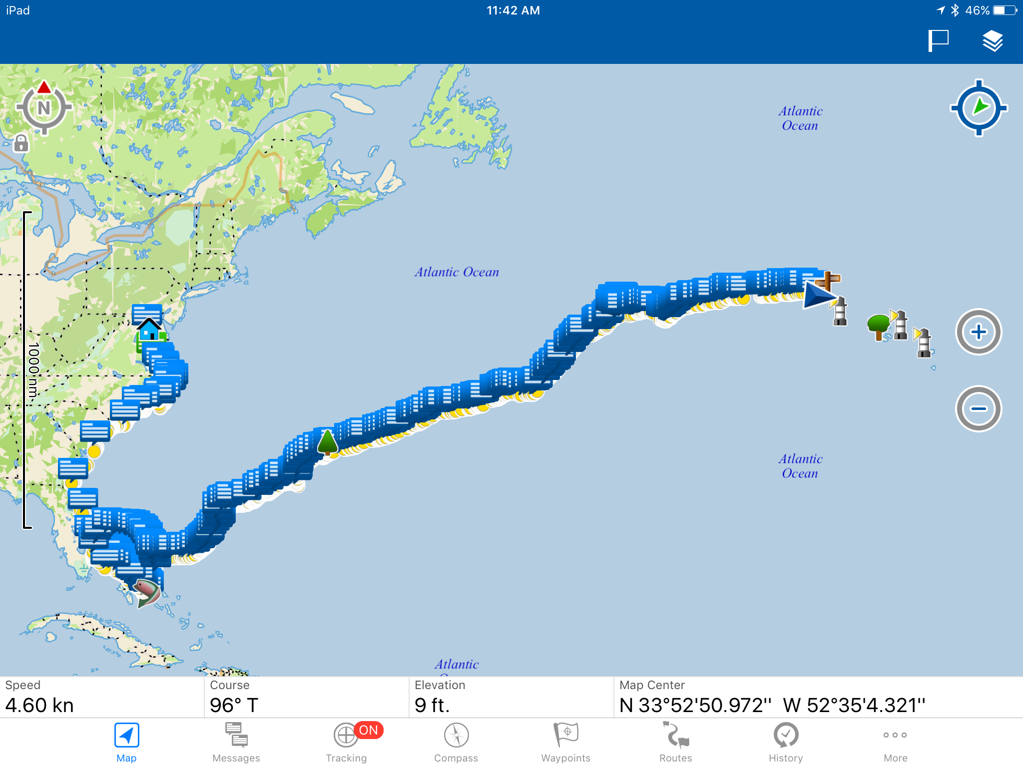
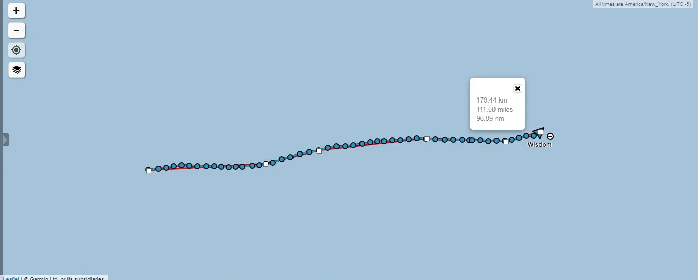
You can see here, we made it to around the area of our little sign post out in the ocean (on this digital map) and began turning towards the Azores! My, how far we have come!

FullSizeRender.jpg

The other good part about staying with the winds is it helps keep us charged up! Our batteries got a little low during that period of no wind that we had. We really like having fresh food on the boat, and to do that, we need to power the biggest most power hungry monster in our yacht: the fridge. This monster chugs the amps and just gives you the cold shoulder! Our house bank got a little low so we were supplying power to the fridge from the motor bank. That drained the motor bank down quite a bit though!

All this fast sailing we are having is great because our electric motor works as a hydrogenerator when sailing fast and that produces the power needed to charge the batteries back up!

Here, the display is saying that we are generating 6 amps at 48 volts. When you step that down to 12 volts (to power lights and the fridge) those 6 amps become 24 amps! That is some serious power it can generate and that is crucial because we will need power when we enter the marina and need to dock.

IMG_2637.PNG

Looking ahead at the information from Predict Wind, you can see that they are calling for the winds to be pretty good for the next few days, and then get kind of light. I don’t really care much for these kinds of charts because it all seems like guesses to me. I like when they are all agreeing, like they do for the first few days (because they are all working with good data) but then the radical spread occurs where one is calling for winds of 4 knots and another is calling for winds of 15 knots! All this tells me is that further out, no one knows and I should just ignore the computer programs and look to the sky to read the clouds.

Clouds tell you the weather you are having and going to have because they are generated by the very weather you are seeing and experiencing. I would much rather look to the sky for my weather than to look at a computer screen generated by a program written by someone who is guessing based on incomplete data.

Transatlantic: Second Week

Week two from Bermuda to the Azores, well, it’s actually 10 days because its a week of ocean time (you know, where time doesn’t matter), was a mix of everything!

First we had no wind and a nice break from all the fast sailing we had done. This gave us time to relax and celebrate my 31st birthday! Then the winds came back and we made our way East towards the Azores.

IMG-3356.jpg

We sailed about 707 miles in these 10 days, averaging 70 miles per day and a speed of 2.9 knots. I know that seems slow, but we actually bobbed around for about 4 days with no wind, and when the winds returned, they were still rather light.

IMG_2811.JPG

The light winds gave us the opportunity to appreciate the ocean in a way few do. Usually, calm conditions is when most cruisers crank on their engines and power their way through to the finish. Hull speed is easily achieved at a modest fuel consumption of around 2 gallons per hour. Cruisers have the fuel to burn and the intolerance for sitting still to justify the expense of the fuel, so off they go at full speed!

Us on the other hand do not have the ability to motor at hull speed for days. Instead, this is when we look out at the horizon and at the fish that are hiding in the shadow of our boats hull. We saw marlin and tuna swimming around our boat, as well as many Man-O-War.

FullSizeRender.jpg

These scary siphonophores are incredibly intricate! I had never before taken the time to notice the detailed pattern of their sail and how their balloon portion is slightly curved like a pastry and somewhat resembling a liver (with the different lobes making it larger on one side and pointy on the other).

FullSizeRender.jpg

We were also graced by the presence of many marine mammals. A whale came to check us out one day and surfaced close to us a few times before diving off into the distance and a massive pod of dolphins came to play with us when we were sailing along at speeds in excess of 6 knots.

IMG_2825.JPG

No matter the time of day, not even if I just came off watch and only want to sleep; the chance to see dolphins in the wild is always a worthwhile moment to be awake!

IMG_2822.JPG
IMG_4160.PNG

This week has also had some interesting neighbors which I identified on the satellite tracker interface. The skull and crossbones is Hurricane Chris, which we were avoiding, the windmill is the next waypoint we should head (according to our friends with Predict Wind), the boat is the position of our Australian friends who left Bermuda a few days before us, and then the islands of the Azores are marked with lighthouses and trees.

FullSizeRender.jpg

Aside from the marine friends we had encountered out there at sea, my second favorite part of this week (and any afternoon at sea actually) are the sunsets. Each is as unique as mathematically possible, and each more interesting than the last; except on cloudless days with an approaching low pressure system, those sunsets are rather boring.

We have been at sea with no sight of land for a long time and we have not seen another human since we left Bermuda, but oddly, we are doing great and enjoying each day at sea for what it has to offer.

Transatlantic: Day 22 [Day 43]

We are nearing the end of July, and also nearing the Azores. Soon we will need to turn South towards the island chain and enter the Azores High, an area plagued by light winds and currents. Normally, cruisers will sail across the Atlantic and then motor the last few days once they lose all wind as they enter the High. We don’t have that luxury, which is why we carry a suit of light air sails. I had these sails (a drifter and a light air mainsail) made out of ripstop nylon (spinnaker material) just so that we would be able to sail once we entered the High ourselves.

IMG-3365.jpg

The closer we can get to the islands without entering the High, the longer we can sail for. To complicate matters further, the Gulf Stream flows through here, so wind or no wind, there is a strong current carrying you to the East. If you miss your island, you might have some trouble sailing back to it against the current with no wind!

IMG_4262.PNG

Our Australian friends were able to receive this information from Predict Wind, but we weren’t able to see it while we were still sailing. They just gave us a brief version in 160 character text messages to our satellite phone. When we did finally meet up in Horta, they gave me all of these screen shots that he had taken of the weather reports.

The forecast is processed by Predict Wind and run through four models. You have the US model, Predict Wind’s version of the US model, the European model, and Predict Wind’s version of the European Model. The information is broken down into various categories and based on the performance of your boat or the conditions you are looking for, you can choose the route that you think will work best.

Talk about gambling!

IMG_4201.PNG

It gets interesting when you throw islands into the mix. Some of the models are saying to go North of Corvo, others are saying to go between Flores and Corvo, and others are saying to go South of Flores.

As you approach Faial, the red model is saying to drop south of Faial and come back up to it, while the green model is saying to go North of Faial and then approach Horta from the East side of the island.

The same information goes in, and yet all four models say something completely different. Out in the ocean, it doesn’t really matter where you go because there is just plain old ocean everywhere. When you throw islands into the mix, you now have wind shadows to contend with and you have to wonder: are these wind shadows accounted for?

FullSizeRender.jpg

We had another bright moon light night to show us that the wind and waves were plenty and strong. We continue to sail East, waiting for the signal in the sky to tell us to turn Southward towards Faial.

Transatlantic: Day 21 [Day 42]

We continue to make our way East but we have removed the Northern component of our course. Why? We have enough wind!

IMG-3364.jpg

The winds in the Westerlies are pretty easy to navigate and sail in because you can choose what kind of winds you want to be having. The further North you go, the stronger the winds will be. The further South you go, the lighter the winds will be. If you feel that the winds are a bit light, simply sail a bit more northerly until the winds build to your liking. If you feel they are a bit too strong, simply head a bit more southerly. When you finally find the winds you like, just head East and the winds will stay constant for you!

FullSizeRender.jpg

While stronger winds do mean larger seas, when they are following seas, they are not so bad!

FullSizeRender.jpg

The waves come at your stern and simply slide under the overhang. The stern lifts and you surf down the wave. As the wave passes the boat, the bow goes up and the boat would normally lose its speed as it tries to climb the back of the wave, but the winds are strong and won’t let you decelerate, powering you along as you ride through the seas.

FullSizeRender.jpg

As night falls, the stars begin to come out. This one star, probably Venus or Jupiter, is already out even before the sun has sunken beneath the horizon. We always reef down in weather like this, not because we want to go slower, but because we don’t want to be reefing in the dark. Should the winds build further, we would be over-canvassed and over-powered, necessitating us to deal with tanbark sails in the dark. Reefing early means that the person on watch simply watches and the person off watch sleeps. Nothing dramatic happens and everyone stays safely well rested.

FullSizeRender.jpg

Thankfully, the Moon is well light in the night as we are making our way towards the Azores. I always prefer to sail at night with a full moon. It makes the mystery of the darkness wash away as your eyes adjust to the small amount of sunlight being reflected back at the surface of the Earth.

It is also very useful to judge the sea state as the moon beam lights up the tops of the waves on its way to your yacht. In your perspective, it might look like a single beam of light leading up to the moon, but everyone has this same perspective as the light from the moon is radiating out evenly in all directions and you are only able to perceive the light that is coming your way; just as someone else can only perceive the light coming their way.

Imagine if we could all see the world from other peoples perspectives? I’m sure there would be a lot less conflict!

Transatlantic: Day 20 [Day 41]

July 27, 2018 and we are approaching the turning point to head back down to the Azores. It has been 20 days at sea with no sight of land, and if we continue on our current course, we will miss the Azores entirely! We need to turn south, but if we do so too soon, we will get caught in the high again. Too late and we will end up sailing extra miles as we fight the Gulf Stream that is running Easterly in this region of the world.

IMG-3363.jpg

Being bored on the boat, I played with the little icons again. The windmill is the waypoint that some of Australian friends said would be good wind and the walking man was a waypoint that a friend on shore in the United States said would be a good waypoint for wind. They are both close, but the interesting thing is they are not the same points, even though they were both using Predict Wind to get this information. Makes me wonder if the program gives reliable information or if the different users were simply inputting different information?

IMG_4162.PNG

The first light house is Flores, the next point, a tree, is Faial (our destination) and the third light house is Terceira. Our Australian friends are currently in Flores and enjoying the wonders of being on land again. We want to check in at Flores to experience the classic “Azores Check-in” and then we have a friend on Terceira that we want to visit once we are checked into the island chain.